 Dig Deep Races
Route card · 60 miles · Saturday 6am
Ultra Tour of the Peak District: the route over 60 miles from Whirlow
- 60 milesDistance
- 3,222 mAscent (2018 route)
- 9 to 22 hCourse times
- 18Minimum age
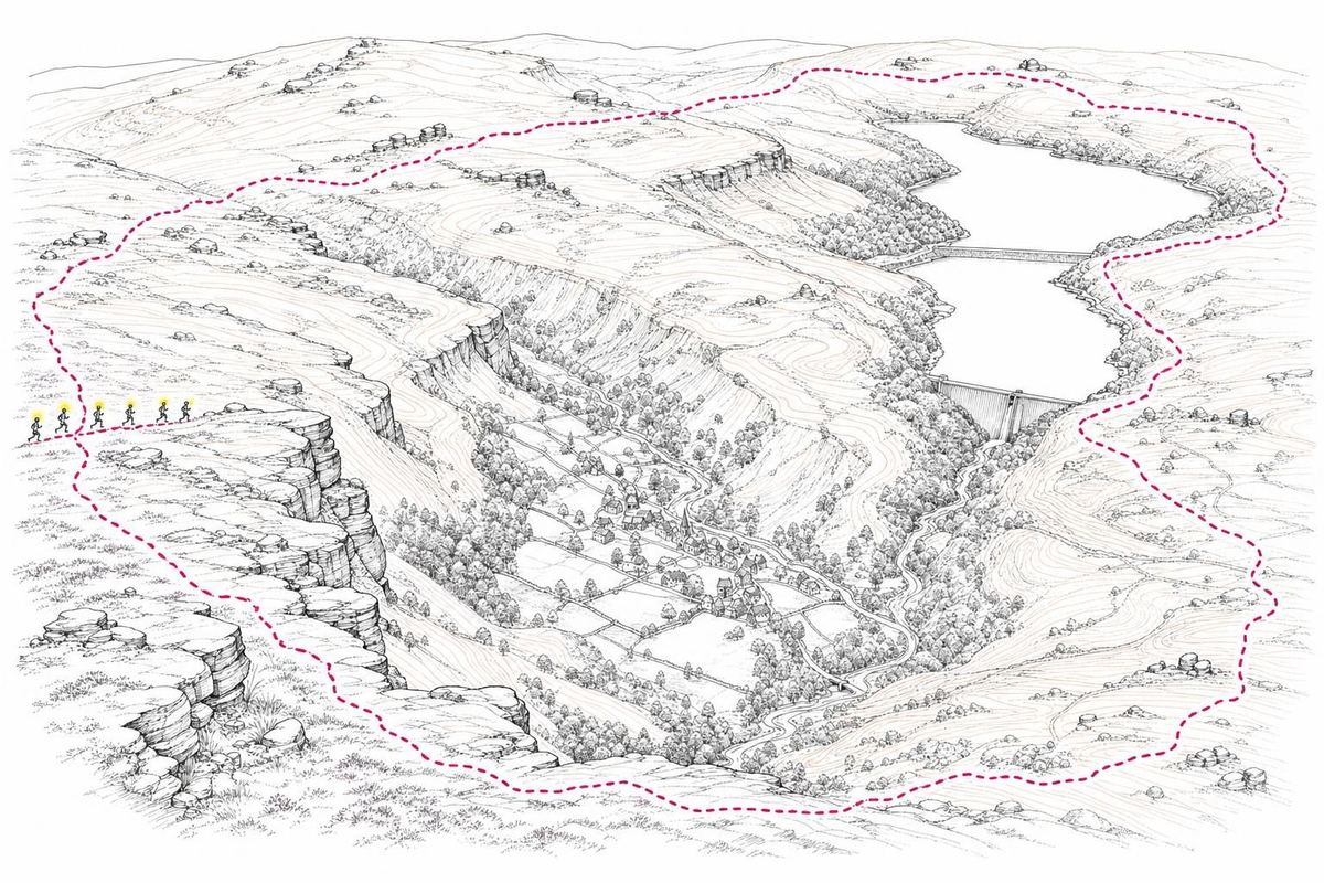
The Ultra Tour of the Peak District is the longest route on this sheet and the best known of the races that started at Whirlow. At around 60 miles, roughly 100 kilometres, it is a full day and often a long evening on the moors and valleys west of Sheffield. It was also a UTMB qualifying race, and the Peak District ultra route described here is the one used for the August race: a loop from Whirlow Hall Farm with support stations at Moscar, the foot of Win Hill and Bradwell.
The race was first run in 2012 and quickly picked up a reputation for being harder than the numbers suggest. Its own briefing notes put it plainly: the drop-out rate is high, so prepare well and be a competent navigator.
The 60 miles in numbers
Two sets of figures exist because the course changed. Until 2016 the published ascent was about 2,722 metres. In 2018, land-use restrictions forced a new line for the long route, and the climbing went up to about 3,222 metres, more than 10,000 feet. Both versions share the same structure: an early start from the farm, a long outward leg into the Dark Peak, and a return through the Hope Valley.
| Figure | Value | Note |
|---|---|---|
| Distance | about 60 miles / 100 km | same on both versions of the route |
| Ascent | 2,722 m (2016), 3,222 m (2018) | the 2018 reroute added about 500 m |
| Start | 6am, Whirlow Hall Farm | briefing at 5.30am in 2016, 5.40am in 2018 |
| Course times | about 9 to 22 hours | as published for 2016 |
| Support stations | Moscar, foot of Win Hill, Bradwell | drop bags transported to each |
| Minimum age | 18 | no upper limit |
| Entry fee | £60 in 2018 | included feed stations, timing, T-shirt, medal and post-race food |
The description that went with those numbers never changed: "no monster climbs", but a continuously hilly course. At 54 metres of ascent per mile on the 2018 line, it climbs at a higher average rate than either of the shorter ultras.
The route, checkpoint by checkpoint
The detailed line was issued to entrants as route notes and a race map, and parts of it changed between years. The checkpoints, though, give the shape of the day.
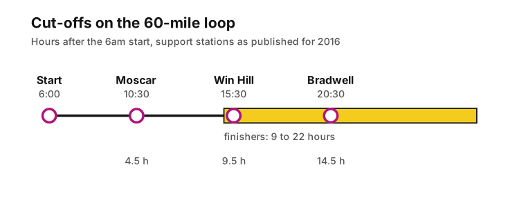
Whirlow to Moscar: the first 4.5 hours
The race left Whirlow Hall Farm at 6am, heading out of the south-western edge of Sheffield and up onto the moors. The first support station sat at Moscar, on the high moorland road that crosses from Sheffield towards the Ladybower valley. In 2016 runners had until 10.30am, four and a half hours after the start, to get there. For a strong runner that is a comfortable margin. For anyone planning on walking the climbs from the off, it is a target worth taking seriously.
Moscar to the foot of Win Hill: the hardest stretch
The second station, at the bottom of Win Hill, closed nine and a half hours in, at 3.30pm. Win Hill is the steep, pointed hill that stands above the Ladybower and Hope Valley area, and the leg from Moscar to its foot had five hours on the clock. Runners near the back arrived here after up to nine and a half hours on the move, which makes it the cut-off to plan around.
Win Hill to Bradwell: into the evening
The third support station was in Bradwell, a village on the southern side of the Hope Valley, and it closed fourteen and a half hours after the start, at 8.30pm. Bradwell also had a practical role: it was the one place on the long route where runners were allowed to leave their head torches behind. Few did. Sunset in late August comes a little after 8pm in the Peak District, so anyone reaching Bradwell near the cut-off had the whole final leg ahead of them in the dark.
Bradwell back to Whirlow: the long way home
The final leg brought runners back towards Sheffield and the farm. Finishing times ran from about nine hours for the front of the race to around twenty-two for the last finishers, which means the last runners were still out at four in the morning.
A UTMB qualifying race from Sheffield
In 2018 the race information listed the Ultra Tour as a UTMB qualifying race worth 4 points towards entry to the Ultra-Trail du Mont-Blanc. That put a UTMB qualifying race within reach of Sheffield, on ground that could be recced in advance.
The qualification system has been rebuilt since then. The old points have been replaced by the "running stones" and index system on the UTMB World Series site, so the 4 points from 2018 say more about how the course was rated at the time than about what it would earn today.
Rules on the Peak District ultra route
- Dibbing. SportIdent dibbing stations sat along the route and every one had to be visited, along with the aid stations. Missing a checkpoint cost a time penalty, and penalties were not changed after the race on the basis of GPS tracks or anecdotal evidence.
- Marking. In 2016 the route was fully marked; in 2018 it was described as partially marked with navigation necessary. In both years poor weather was expected to make navigation part of the race.
- Restrictions. Some sections carried strict route restrictions agreed with landowners and the Peak District National Park Authority. Runners had to follow them wherever they were marked.
- Poles and pacers. Poles were allowed. Pacers were not.
- Drop bags. At registration, runners could hand in bags marked with their name and a support station number, 1, 2 or 3, which were taken out to the stations.
- Registration. All runners on the long route were asked to register the evening before. Morning registration from 5am was for emergencies only.
Mandatory kit for the 60 miles
The mandatory list was the same in 2016 and 2018:
- full body cover, windproof and waterproof
- compass and full route map
- spare water and food
- whistle
- head torch
- mobile phone
It is a minimal list for a 100-kilometre day on high ground, and most experienced runners added to it: a warm layer for the evening, spare batteries for the torch, a small first aid kit and enough food to cover the gap if a support station runs short. A course that can take twenty-two hours will see the temperature drop sharply after dark, even in August.
How to train for the Ultra Tour
The single most useful thing is time on similar ground. The Peak District ultra route rewards legs that cope with constant small climbs and descents, not a single long hill, so training on the moors around Sheffield beats any amount of flat mileage.
- Build back-to-back long days. A long run on Saturday followed by a medium one on Sunday teaches the legs to work when tired, which is what the second half of the race feels like.
- Practise walking the climbs. Almost nobody runs every climb on a 60-mile course. A strong, fast hike is worth more than an ambitious run that blows up after Moscar.
- Train descending. Quads give out on the downhills long before lungs give out on the climbs. Regular steep descents in training make the final third much kinder.
- Recce the route in sections. The support station villages split the loop into manageable chunks, and the Hope Valley railway makes it possible to run a section and take the train back into Sheffield.
- Run some of it in the dark. Most finishers spend the last hours under a head torch. Practising night running on familiar paths takes a lot of the stress out of that part.
- Eat on the move. Fourteen hours to Bradwell is a long time to run on a few gels. Test real food on long training days.
Anyone stepping up from a shorter race should look at the Peak Trails 50 first. It shares the 6am start and much of the character of the long route, and it is a fairer test of whether the full 60 miles is the right next goal. The route sheet on the homepage compares all five distances side by side.
Questions about the Ultra Tour of the Peak District
How long is the Ultra Tour of the Peak District?
About 60 miles, or roughly 100 kilometres.
How much climbing is on the route?
About 2,722 metres on the route used up to 2016 and about 3,222 metres on the rerouted course from 2018.
Where were the support stations?
Moscar, the bottom of Win Hill and Bradwell. Drop bags marked 1, 2 or 3 were transported to each.
What were the cut-offs?
In 2016: Moscar at 10.30am, the foot of Win Hill at 3.30pm and Bradwell at 8.30pm, measured from a 6am start.
How long do finishers take?
The published course times ran from about 9 to 22 hours.
Was it a UTMB qualifying race?
Yes. In 2018 it carried 4 qualifying points for the Ultra-Trail du Mont-Blanc under the system in use at the time.
Is the route marked?
Fully marked in 2016 and partially marked in 2018, with navigation expected in poor weather in both years.
Can head torches be left behind?
Only at the Bradwell support station. Everywhere else the head torch was part of the mandatory kit.
Are poles allowed?
Yes. Pacers were not allowed.
Is the Ultra Tour suitable for a first ultra?
Not really. The 30-mile Peak Trails race was designed for first-time ultra runners; the 60-mile route expects ultra experience and navigation skills.